Wanderung Pfad Plateau Saint Valentin
Sportaktivitäten, Laufsportarten, Fußwanderungsstrecke
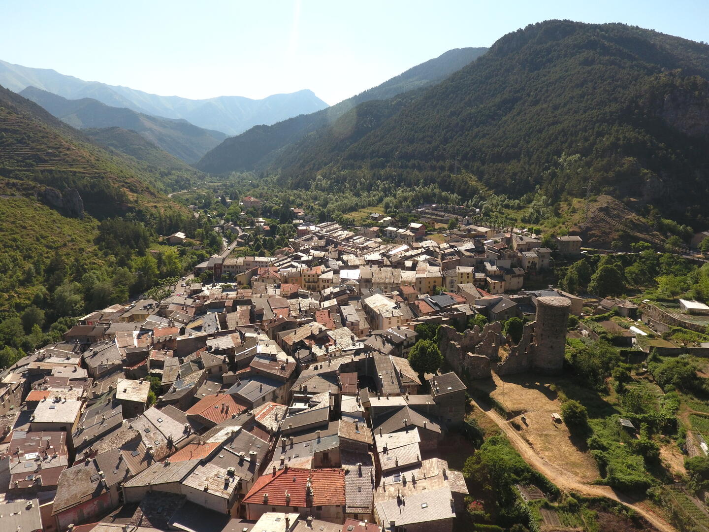
Um La Brigue
1.2
km
-
Leichte Wanderung vom Dorf aus mit schönem Aussichtspunkt
-
Gehen Sie in den mittelalterlichen Ortskern des Dorfes und erreichen Sie die Markierung 47 auf der Höhe des Place Casali. Ein Anstieg auf einer Calada (Kieselsteinpflaster) führt Sie zu den Ruinen des Schlosses Lascaris. Folgen Sie dem Weg bis zu einer kleinen Kreuzung zwischen Gemüsegärten; nehmen Sie den Weg, der weiter bergauf führt. Sie kommen an einem rosafarbenen Haus vorbei und erreichen die Markierung 43; Sie müssen dem Weg weiter folgen, der links bergauf führt. Sie gelangen nun auf...
Gehen Sie in den mittelalterlichen Ortskern des Dorfes und erreichen Sie die Markierung 47 auf der Höhe des Place Casali. Ein Anstieg auf einer Calada (Kieselsteinpflaster) führt Sie zu den Ruinen des Schlosses Lascaris. Folgen Sie dem Weg bis zu einer kleinen Kreuzung zwischen Gemüsegärten; nehmen Sie den Weg, der weiter bergauf führt. Sie kommen an einem rosafarbenen Haus vorbei und erreichen die Markierung 43; Sie müssen dem Weg weiter folgen, der links bergauf führt. Sie gelangen nun auf einen Teil des GR52A.
In Richtung der Markierung 43 passieren Sie etwa zehn Serpentinen, die im Zickzack in Etagen verlaufen, je weiter Sie kommen. Sie sind nun höher als die Stiftskirche Saint Martin. Bei der Markierung 43 gehen Sie geradeaus in Richtung Dorf durch ein Unterholz, das sich nach einigen Metern auf das berühmte Plateau Saint Valentin öffnet, das auch "erstes Plateau" genannt wird.
Man gelangt auf alte Beete, die früher bewirtschaftet wurden... Gehen Sie weiter in Richtung des Panoramas, das auf der Höhe des Sendemastes freier ist. Genießen Sie die Aussicht!
Zurück auf demselben Weg oder über das zweite Plateau :
Die zweite Hochebene ist die, die man rechts überholen sieht; zum Preis von einer halben Stunde Gehzeit und 150 zusätzlichen Höhenmetern, wenn man die Markierung 243 erreicht und mit möglichem Abstieg durch das Riodore-Tal bis zur Markierung 250. Achtung, dieser Weg wird von Herden begangen und ist sehr, sehr steil!
- Abfahrt
- La Brigue
-
- Ganzjährig.
-
-
Gesprochene Sprachen
-
-
-
-
-
Dokumentation
- Mit GPX / KML-Dateien können Sie die Route Ihrer Wanderung zu Ihrem GPS (oder einem anderen Navigationswerkzeug) exportieren
-
- Alle Kommentare ansehen