Wanderung Schleife des Col Linaire
Sportaktivitäten, Laufsportarten, Fußwanderungsstrecke
Um La Brigue
11.8
km
-
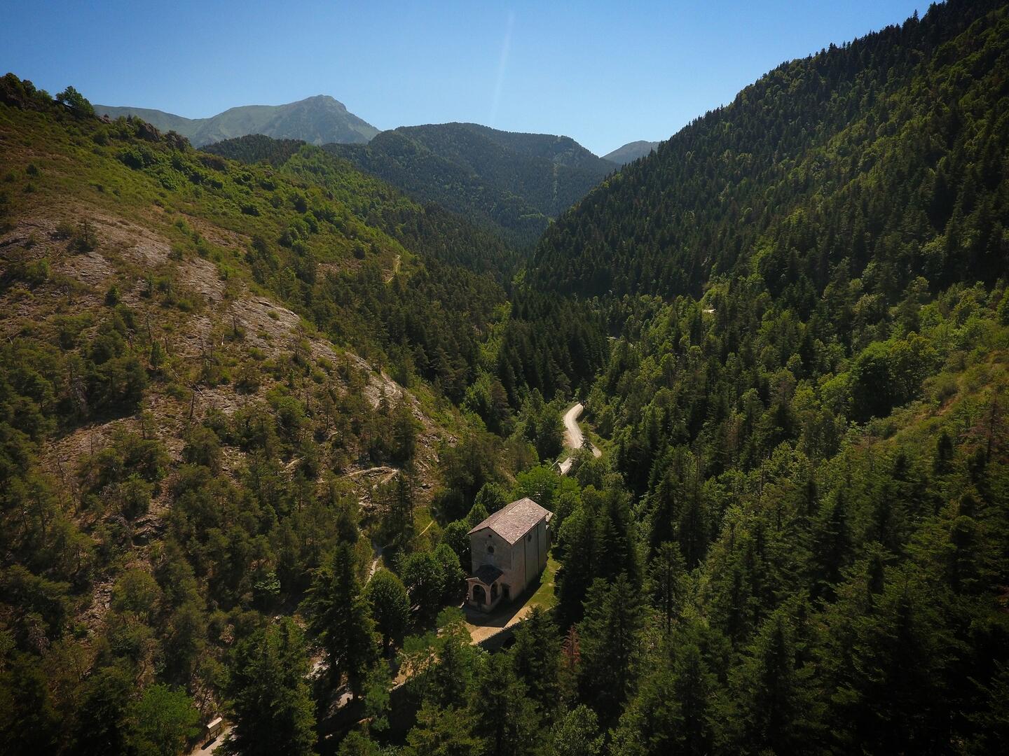
Ein Rundweg durch die Wälder von La Brigue, vorbei am Col Linaire und Notre Dame des Fontaines mit seinen berühmten Quellen.
-
Starten Sie am Place St Martin und folgen Sie der Straße entlang des Flusses zum Place de Nice (zentraler Platz des Dorfes). In einer Ecke des Platzes finden Sie einen Brunnen und eine Straße, die in das Dorf hineinführt. Nehmen Sie die Straße und gehen Sie links weiter in die Rue Lanteri. Folgen Sie ihr, gehen Sie durch den rechten Torbogen und biegen Sie dann links in die Rue du Colonel Dullin ein. Folgen Sie der Steigung nach den Garagen auf der rechten Seite. Gehen Sie an der Schule und...
Starten Sie am Place St Martin und folgen Sie der Straße entlang des Flusses zum Place de Nice (zentraler Platz des Dorfes). In einer Ecke des Platzes finden Sie einen Brunnen und eine Straße, die in das Dorf hineinführt. Nehmen Sie die Straße und gehen Sie links weiter in die Rue Lanteri. Folgen Sie ihr, gehen Sie durch den rechten Torbogen und biegen Sie dann links in die Rue du Colonel Dullin ein. Folgen Sie der Steigung nach den Garagen auf der rechten Seite. Gehen Sie an der Schule und dem Friedhof vorbei und folgen Sie dem Beginn des Pfades an der Markierung 48, direkt neben einer Kapelle. Folgen Sie dem Weg durch den Wald, vorbei an den Markierungen 258 und 259. Bei letzterer überqueren Sie vorsichtig den Weg und gehen auf dem gegenüberliegenden Weg weiter in Richtung der Markierung 260, die unter dem Gipfel des Pinet verläuft. An der Markierung vorbei taucht der Col Linaire auf, eine große Ebene an der Wegkreuzung. Folgen Sie dem flachen Weg auf der linken Seite, es ist ein Waldweg. Erreichen Sie die Markierung 262. Folgen Sie dem Weg, der sich ganz in der Nähe des Vallon de Noce entwickelt, bis zur Markierung 263. Am unteren Ende des Weges überqueren Sie das Tal, das in eine kleine Lichtung im Vallon de la Madone mündet. Gehen Sie an den Markierungen 264, 265 vorbei bis zur Kapelle Notre Dame des Fontaines. Nutzen Sie die Gelegenheit, um diesen magischen Ort zu entdecken. Kehren Sie über den Interpretationspfad, der 50 m unterhalb der Kapelle auf der Straße links beginnt, in das Dorf La Brigue zurück. Folgen Sie dem Weg, vorbei am Kalkofen und weiter bis zur Ankunft im Dorf.
- Abfahrt
- La Brigue
-
-
Ganzjährig.
Unter Vorbehalt günstiger Wetter- und Schneeverhältnisse.
-
-
Umwelt
-
-
-
Gesprochene Sprachen
-
-
-
-
-
Dokumentation
- Mit GPX / KML-Dateien können Sie die Route Ihrer Wanderung zu Ihrem GPS (oder einem anderen Navigationswerkzeug) exportieren
-
- Alle Kommentare ansehen